


The beat (and the heat) goes on…
For many in southern New England, today will mark the 6th straight day with high temperatures in the upper 80s to low 90s. And, as the old saying goes, “it ain’t the heat, it’s the humidity”! Day after day we have had oppressive, swelteringly humid air in place. In fact, through the first 10 days of July, we are racing towards one of the most humid months on record (currently just behind last July).
Temperatures are nowhere near record-breaking; we are not talking about 100-degree heat like we nearly had back in June or DID have back in 2022…but it is more the relentlessness of the heat and humidity this time around. I regret to inform you that we have a LONG ways to go before any real relief comes our way.
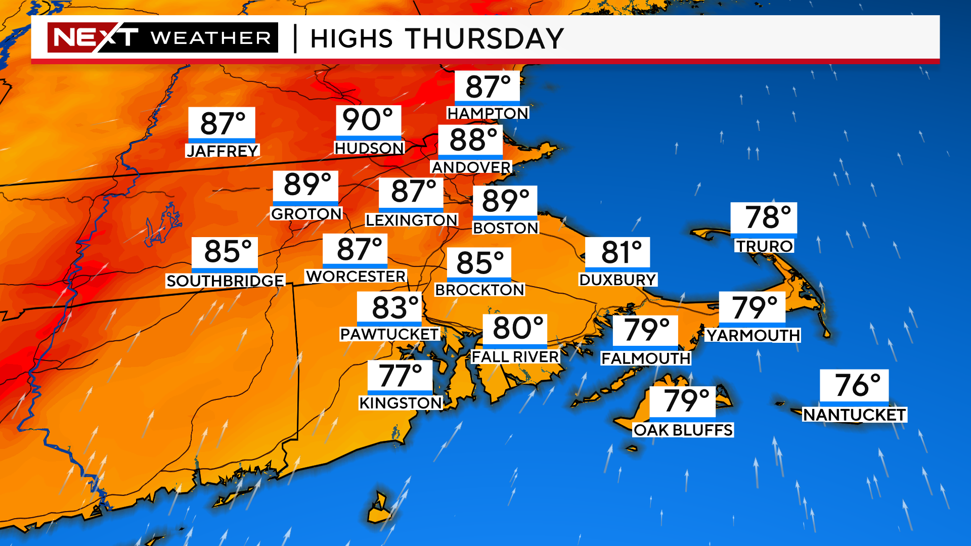
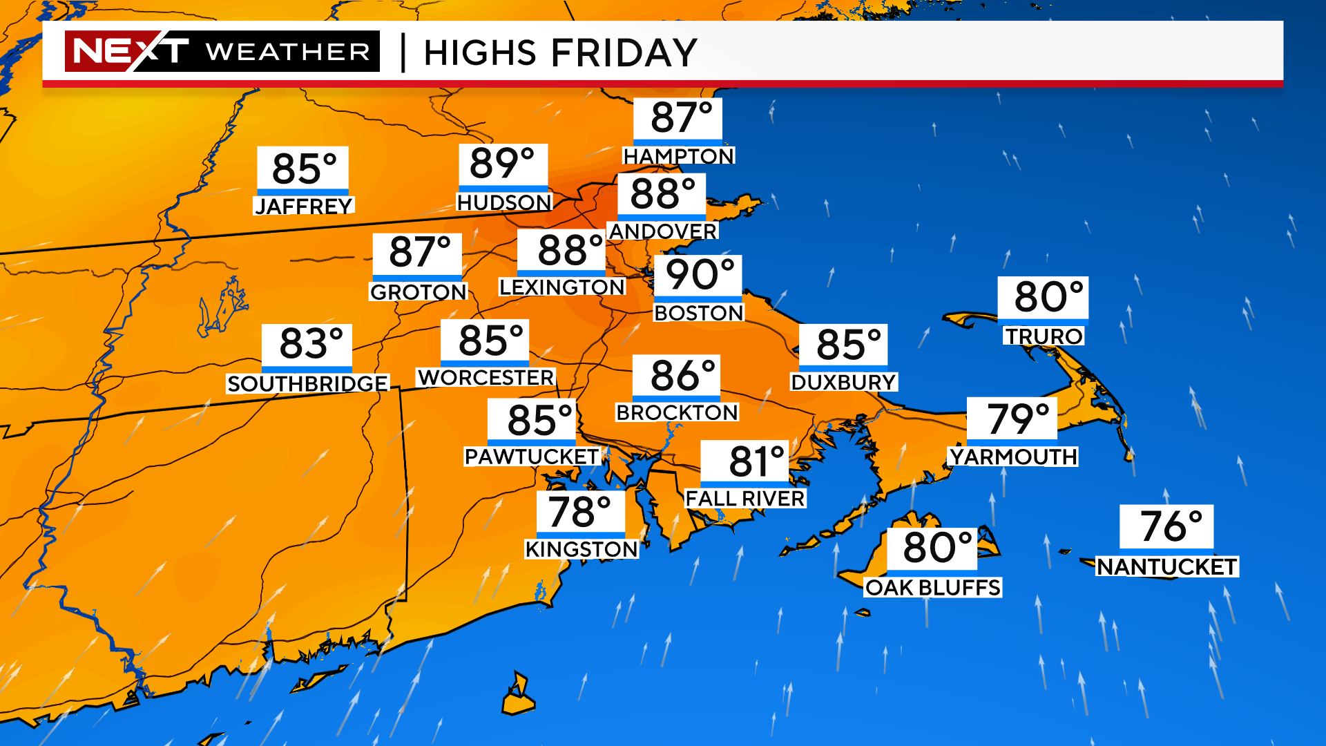
The next several days are more of the same…
Highs near 90, dewpoints about as high as they get around here.
Today and Tomorrow the dewpoints across most of our area will reach the mid 70s. That is quite rare, something normally felt in the Deep South, say in New Orleans.

And again, the kicker is that there is no fresh, crisp, Canadian airmass that is on its way to save the day.
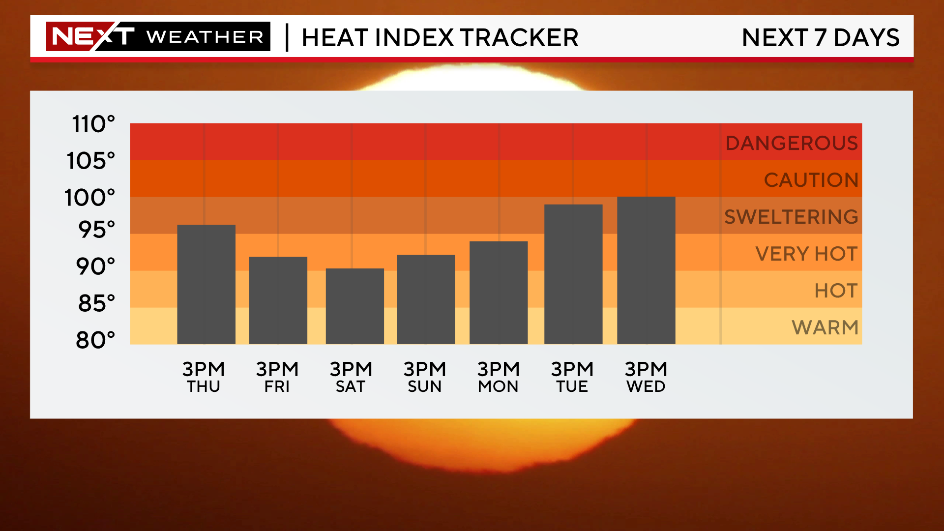
Looking at the “feels-like” temperatures for the next 7 days, you can see we never dip below 90 and, in fact, we expect things to get worse before they get better. It appears there will be another spike in heat and humidity early next week.
Many have asked…”is this an official heatwave”?
The short answer is, does it really matter?
As a reminder, an official heatwave here in the Northeast is loosely defined as at least 3 consecutive days with temperatures 90 degrees or higher.
So, going by the books, there is NO heatwave in Boston or Worcester. They haven’t even hit 90 yet in this current stretch!
Travel a bit north and west and temperatures have been a few degrees hotter. In places like Bedford and Fitchburg (and much of the Merrimack Valley) we do in fact have an official heatwave as of Tuesday.

Kind of silly right? I agree. This is why I don’t think we should get too caught up in declaring a heatwave or not.
Go online and you will find all sorts of different definitions of what constitutes a heatwave. Three days of 90-degree heat in places like Dallas or the Desert Southwest might be considered a “cooldown”.
The National Weather Service defines it as “a period of abnormally hot weather usually lasting more than 2 days…with or without high humidity”.
Basically, it is all relative. Each area of the Country and the World defines their heatwaves by what their typical weather or climatology is.
Blah blah blah…This is just a long way of saying, official heatwave or not…it is going to be uncomfortably hot and humid for at least the next 7 days.
Best guess as to when this pattern breaks…later next week. Most models point towards a cooler and drier airmass arriving around next Thursday but that is a long way off and things could easily change.
I would also anticipate that the current pattern is likely to repeat itself several times through the remainder of summer. The Oceans are exceedingly warm, La Nina is coming on…several factors are lining up that would lead us to conclude the heat and humidity are here to stay.
Click here for Westford snow storm data and past totals or select “Winter Snowfall“ under “Pages” on the left hand side.
For more up to date forecast information follow me on Twitter (@terrywbz) or follow the WBZ weather team on Facebook, search WBZWeather
Reader Comments