


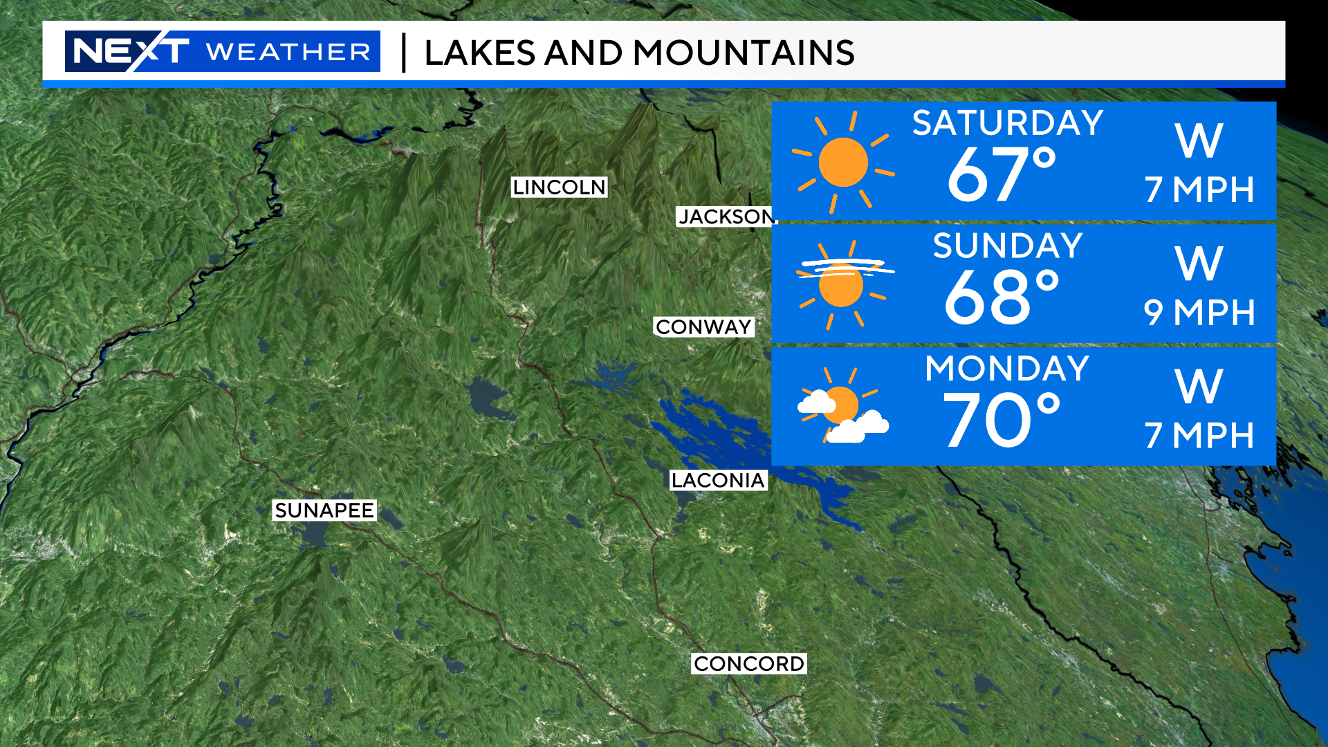
WHAT A WEEKEND! In fact we have sunshine and warm temperatures in the forecast through the middle of next week!
The Fall season continues to fly by. The sun is now setting before 6pm in the evening, we had our first widespread frost this week and many of the northern Mountains have seen their first snowfall!
We are now in “snowliage season” up north. The beautiful time of year when the bright fall colors mix with the first snow on the Mountaintops.

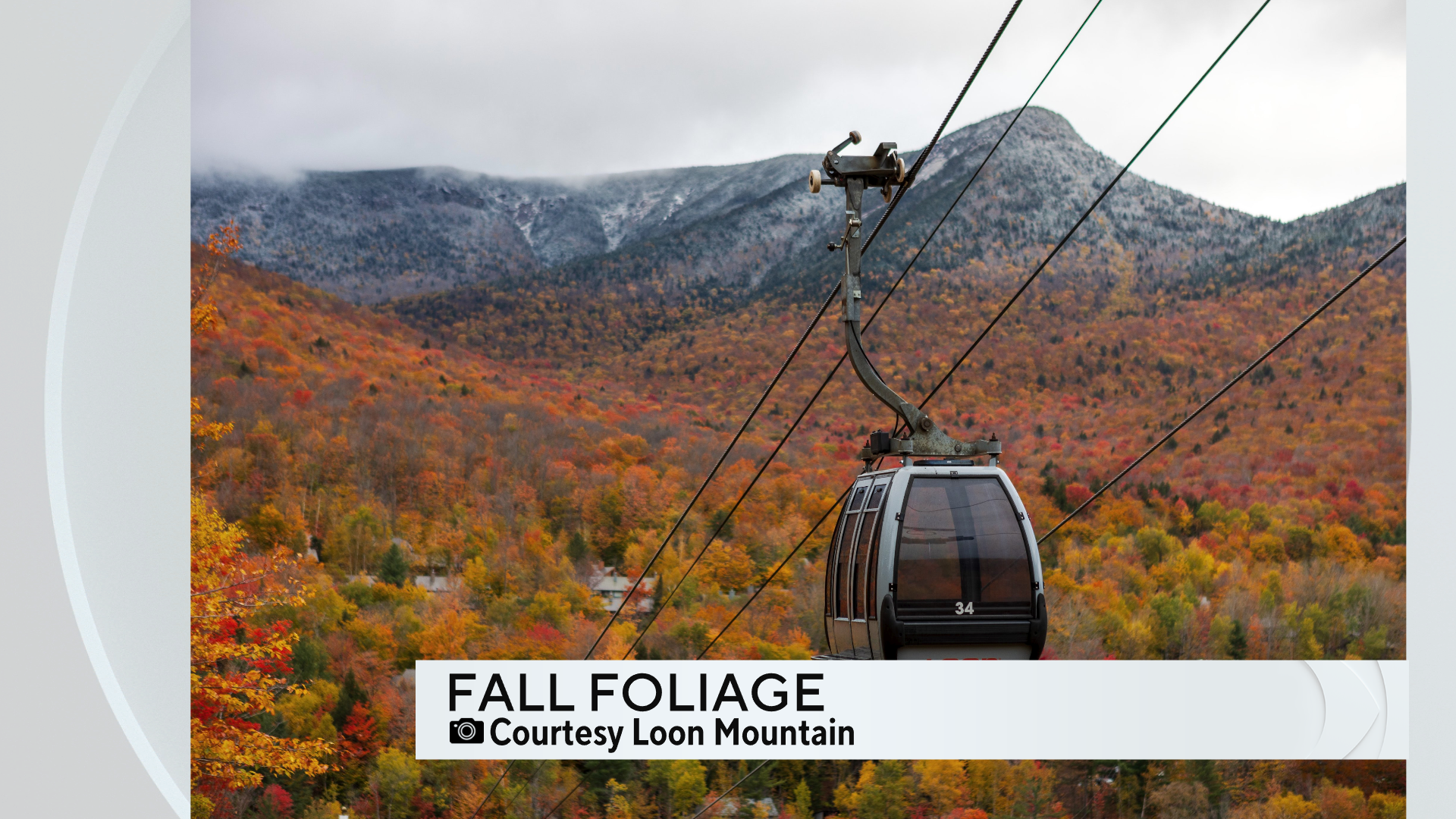

You can probably tell from these pictures, foliage season is just about done in the Mountains of northern New England.
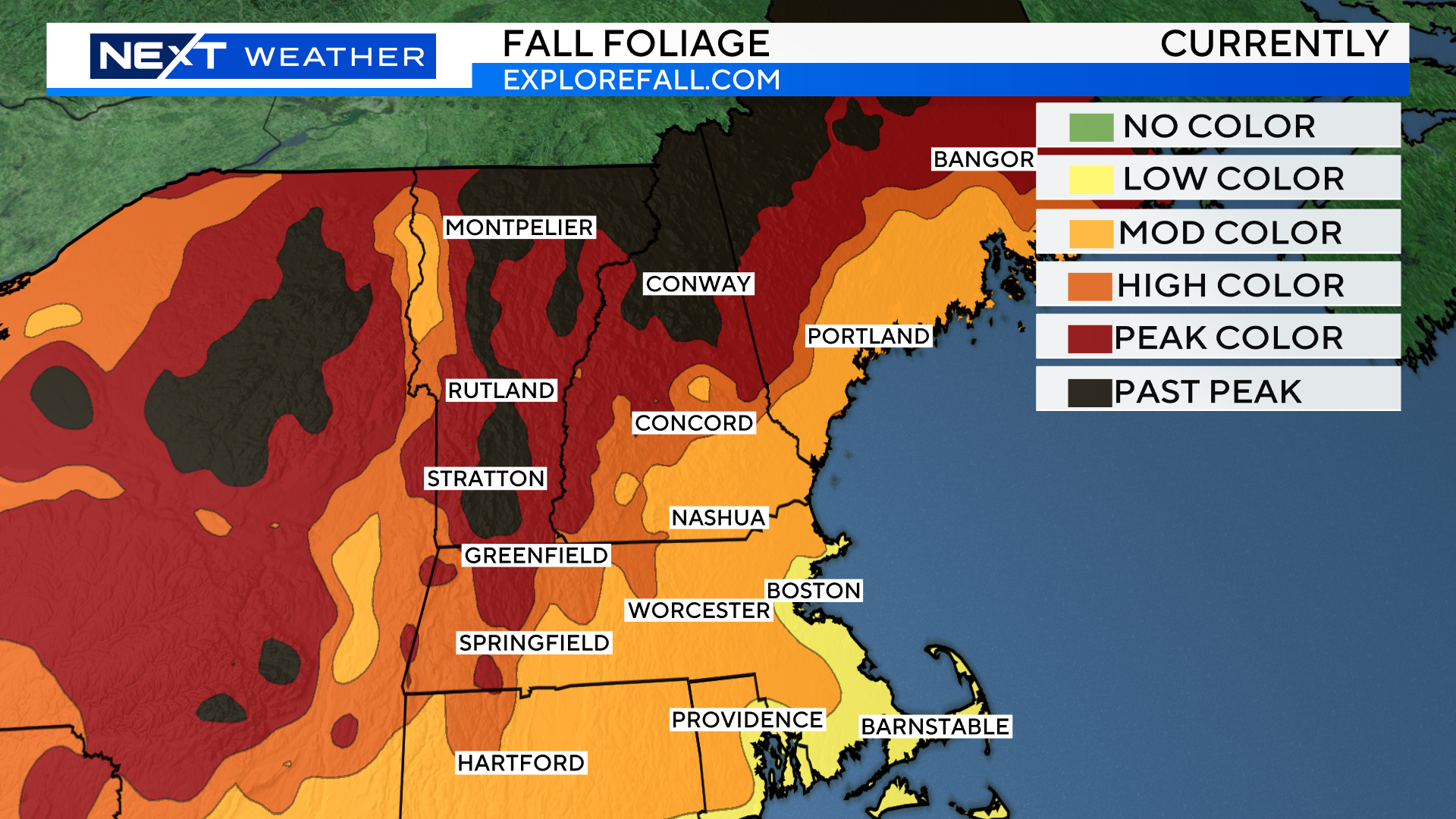
However, there are still lots of foliage “hot spots” to visit this Weekend and many are closer to home!
A few suggestions where you will find peak or near peak color…
-Take a drive up the Seacoast of New Hampshire and Maine
-Head up route 3 or 93 into New Hampshire and explore the Lakes Region, near Winnipesaukee.
-Hike Mount Monadnock in southwestern New Hampshire
-Take a ride west down route 2 and check out the Quabbin or Pioneer Valley area
-Finally, you will see areas of peak color right here in eastern MA! Especially out towards 495 in the Groton area.
The weather forecast literally could not be better. There will be sunshine from Mountaintop to Seashore all Weekend long. Temperatures will be comfortable, upper 60s up north and low 70s in southern New England. Finally, there will be very little wind… truly no excuse not to get out and enjoy one of the best times of year here in New England!
WINTER FORECAST
NOAA issued their 2024-2025 winter forecast this week…
Not surprisingly, NOAA based a large portion of their forecast on something we call ENSO (El Nino Southern Oscillation). Last winter it was all about El Nino. This year, the opposite. The National Weather Service is forecasting a 60% chance of a La Nina this winter.
While El Nino is primarily characterized by warmer than normal ocean temperatures off of South America, La Nina’s signature is cooler than normal water in that same region.

So, given this forecast, we should expect a winter that is opposite from last right? Well, yes and no.
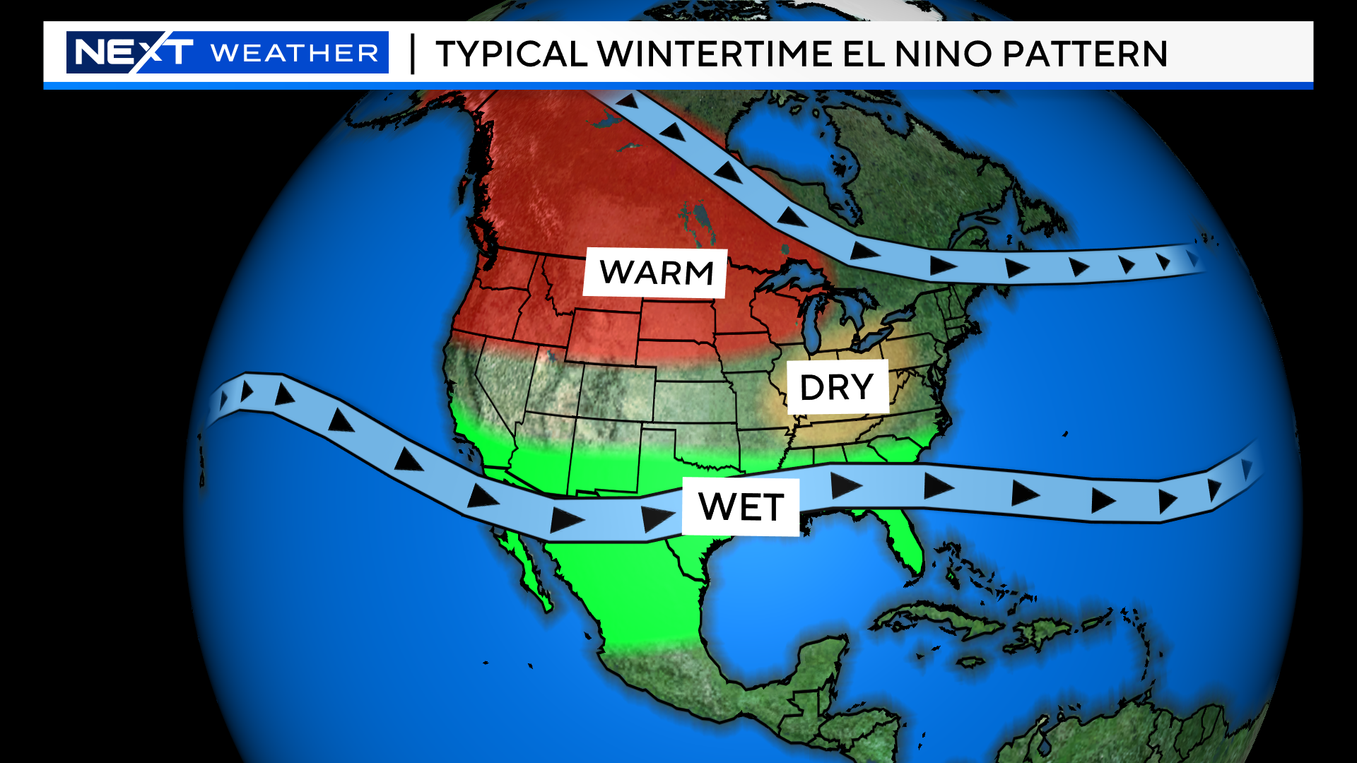
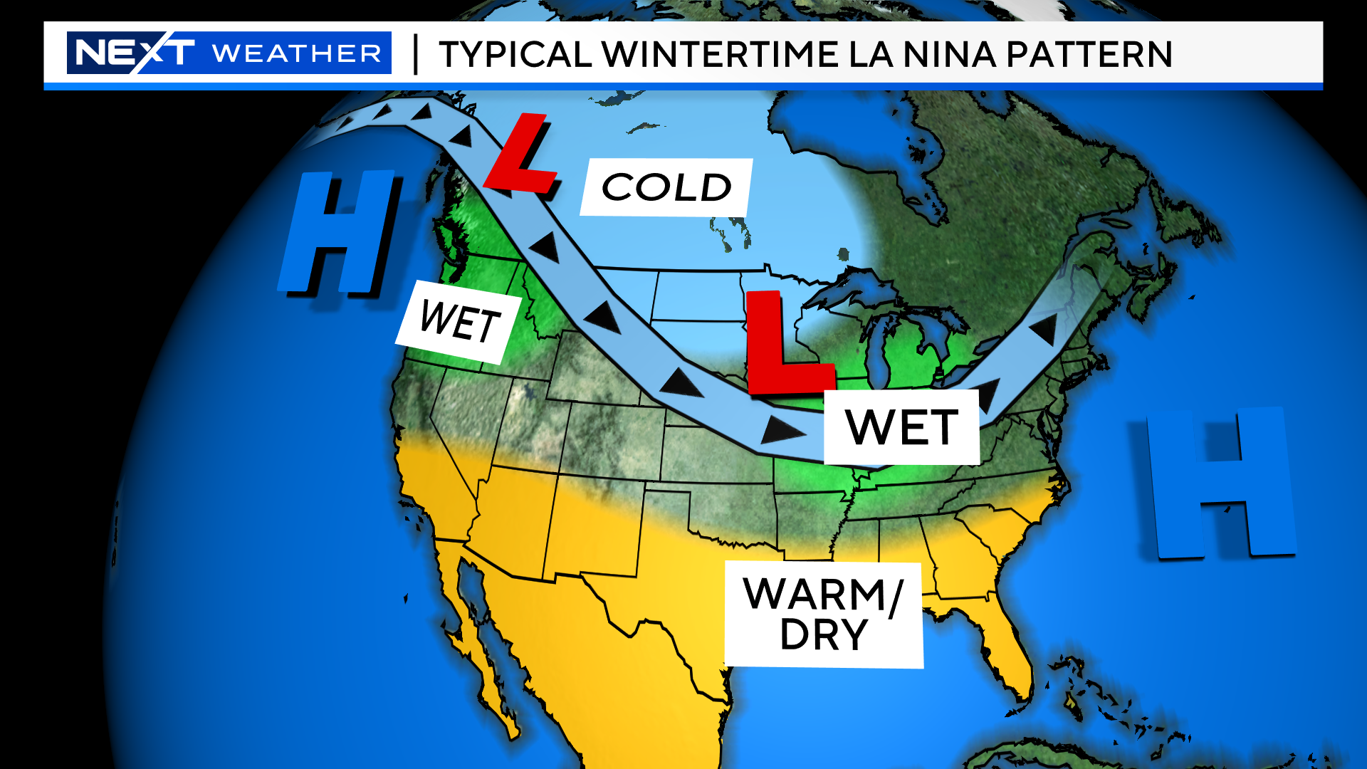
If you look at the “typical” patterns across the Country we see large differences between El Nino and La Nina.
The Pacific Northwest is normally warm in El Nino’s and cold/wet in La Nina’s.
The Ohio Valley is typically dry in El Nino’s but wet in La Nina’s.
The entire southern tier of the U.S. flips from cool and wet during El Nino’s to warm and dry in La Nina’s.
What about us here in the Northeast? Well, the impacts and differences are not as obvious or stark. If often depends on the strength of the El Nino or La Nina. Last year a relatively strong El Nino led to a very warm, snowless winter here.
This year we are expecting a weak La Nina. This likely won’t lead to any major impacts here, but instead, will allow for “other” large scale atmospheric factors to play a bigger role. This includes things like Ocean temperatures in the Pacific and Atlantic, the Polar Vortex and any blocking that may develop across Canada/Greenland. This makes the winter forecast much more difficult to predict here in the Northeast.
NOAA’s forecast looks a lot like a typical La Nina.
Milder than average temperatures across the south and up the East Coast and colder than average in northwestern Canada down through the Upper Midwest.
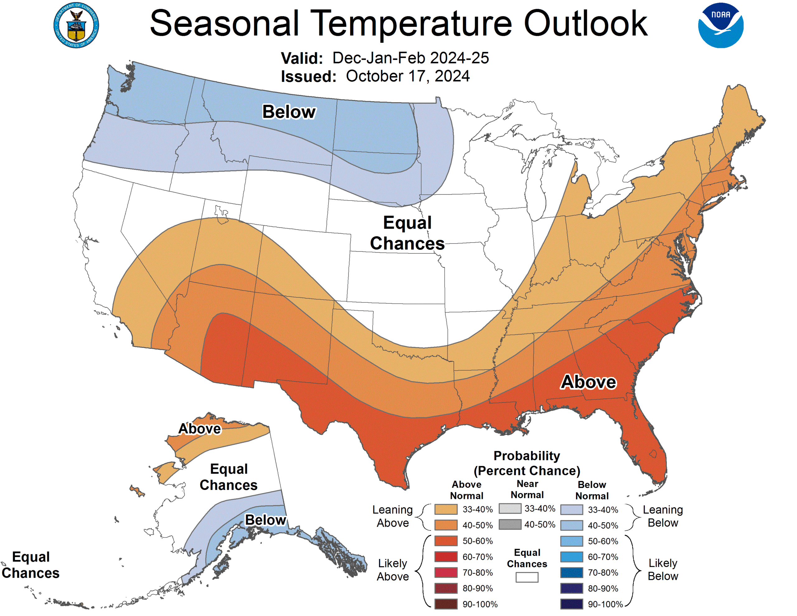
As for precipitation, again a very typical La Nina look. Dry across the South and wet in the Ohio Valley.

The WBZ Weather Team will make our official winter prediction in November. However, at this point, I do not see any major reason or evidence to dispute the NOAA forecast. We haven’t had a truly cold winter here since 2014-2015 and the snowfall amounts in recent years have been laughably low. Given the current state of our Oceans and atmosphere, I think it will be exceedingly difficult to get a below average (temperatures) winter season. Sure, there will be some periods of cold and SOME snow…but the early odds favor yet another mild winter for southern New England in 2024-2025.
Our team will continue to monitor all the various, complex atmospheric factors that will play into the upcoming winter. As things unfold in the weeks ahead, we will keep you updated as to how things are shaping up and what you can expect this winter!
Click here for Westford snow storm data and past totals or select “Winter Snowfall“ under “Pages” on the left hand side.
For more up to date forecast information follow me on Twitter (@terrywbz) or follow the WBZ weather team on Facebook, search WBZWeather
Reader Comments