


Wintah is here! Plenty of wind and cold on the way, but news for snow lovers isn’t great…
Quick summary of the next 48 hours…
Coldest night of the season thus far tonight…temperatures drop into the single digits and in some cases below zero
Dangerous, unrelenting winds through Saturday morning, delivering wind chills -10 to -25 degrees
Sunday morning stays brutally cold, albeit without the wind…temperatures only recover into the teens and 20s Sunday afternoon.
Most of our area, including Boston, will spend this entire weekend well below freezing (32 degrees)
How do you follow up one of the coldest weekends in years? Naturally, with rain on Monday. That’s just how we roll here in Boston.
It won’t be all rain though…
Friday night…
Some rain showers change to snow showers over Cape Cod and the Islands and taper off by about 10pm. Very little accumulation expected. Winds ramp up and peak from about 6pm-6am.
Expect frequent north to northwesterly gusts between 30-40mph west of I95, 40-50mph along the immediate Coastline and 50-65mph over Cape Cod and the Islands. This could be just enough to create some isolated power outages Friday night along with some scattered wind damage.
Saturday…
Combine those winds with another round of Arctic air and you’ve got yourself a rather miserable Saturday. Wind chill values will drop as low as -15 to -25 degrees Saturday morning. Winds relax by afternoon and we “recover” to wind chills between 0 to -10 for the rest of the day. Actual high temperatures on Saturday will be in the teens for most, perhaps some single digits well to the northwest.
Sunday…
The winds no longer a concern but the cold remains. Morning lows a few degrees on either side of zero for most and highs for the day in the 20s by afternoon.
Sunday night & Monday
And would you believe, after all that cold, we are looking at a mostly rain event on Monday morning? Without any blocking present across northern latitudes, this storm is going to literally head right up the gut, through Southern New England. Most of our classic snowstorms encounter some resistance up this way and end up passing just south of Nantucket, leaving us on the cold side…not this time. While most of southern New England will start as a brief period of snow, for many, it won’t last long. Expect the precipitation to arrive between 2-4am Monday morning. Should start as snow everywhere west of I95, likely all rain east of that. The heaviest rain and snow occurs between 6am and 1pm Monday and we expect the rain/snow line to make significant northward progress during that timeframe.
Estimated “changeover” from snow to sleet/rain:
Right away: Boston, Coastline, SE MA
6-8am: 495 area from Marlboro to Westford to Andover
8-10am: northern Worcester county, to southern New Hampshire…essentially by 10am the only snow left in Massachusetts is in the Berkshires
The snow “jackpot” from Monday’s storm will be out in New York State and far northern New England where 8-12”+ will fall.
Locally, the highest snow totals will be found in elevated areas in extreme northern Worcester county and the Berkshires, 4-8”.
Snow totals diminish quickly to the east and south…expect 2-4” before the change down I90 and for most of Worcester county.
Between 128 and 495, a quick coating to 2”, likely all washed away by the change to rain.
And again, all rain in Boston and along the immediate Coastline down through Cape Cod.


For eastern MA, the main concern will be the wind. We could see gusts out of the south-southwest between 50-70mph close to the Coast and especially over Cape Cod and the Islands during Monday morning. There could even be some embedded thunderstorms in the heavy rain area!
This storm is another quick mover though, the rain/snow and wind will quickly taper around midday and things will quiet down significantly in the afternoon.
No big storms likely in the days to follow, just more cold. Highs generally look near to slightly below average for most of next week. Next window for another storm appears to be around the following weekend.
Saturday’s Playoff Opener Against Bills Could Be Third Coldest Game In Patriots History
By Terry Eliasen, Meteorologist, WBZ-TV Exec. Weather Producer
BOSTON (CBS) – I’ve got to admit, after the Pats started the season 2-4, I didn’t expect I would be writing a blog this season discussing playoff weather. But after a 7-game win streak and a rather shaky end to the season, here we are!
The Patriots are headed to Buffalo this Saturday night to face the Bills in the first round of the NFL playoffs. Would you believe this is the first ever meeting between the two teams in the playoffs? Crazy!
Back in Week 13, when I blogged about the forecast for their matchup in Buffalo, I predicted a low scoring, Patriots victory, thanks largely in part to a very windy forecast. The Pats leaned heavily on their running game (like, historically heavy) and eked out a win with winds gusting and swirling all night. The weather was so bad that kicking a field goal was nearly impossible and Mac Jones only threw the football just three times. It was classic Patriots, or should I say, classic Bill Belichick.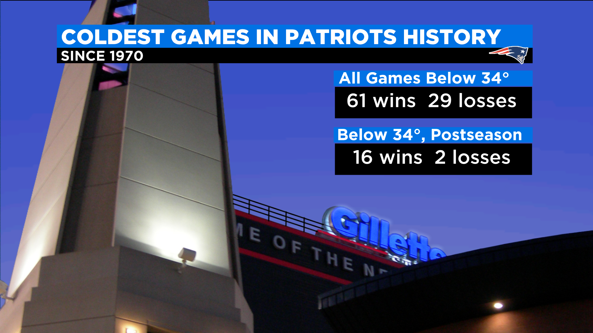
(WBZ-TV Graphic)
Over the years, the Patriots have capitalized on bad weather like no other team. Most notably, under Bill Belichick and Tom Brady, they were nearly unbeatable in the cold and snow in the postseason. In cold weather games (kickoff temperature 34 or lower) they amassed a 16-2 record.
If you look at their entire history since 1970, the Patriots have a 61-29 record in games 34 or colder at kickoff.
So, just given those stats, you would logically assume that the Patriots would have a distinct advantage given the forecast this Saturday in Buffalo, right?
Here is where we must insert the biggest “yeah but” ever in the history of “yeah buts.” Tom Brady ain’t walking through that door. Mac Jones has never played in a game with temperatures colder than 30 degrees in his life. Growing up in Florida and playing college in Alabama doesn’t exactly expose you to the elements.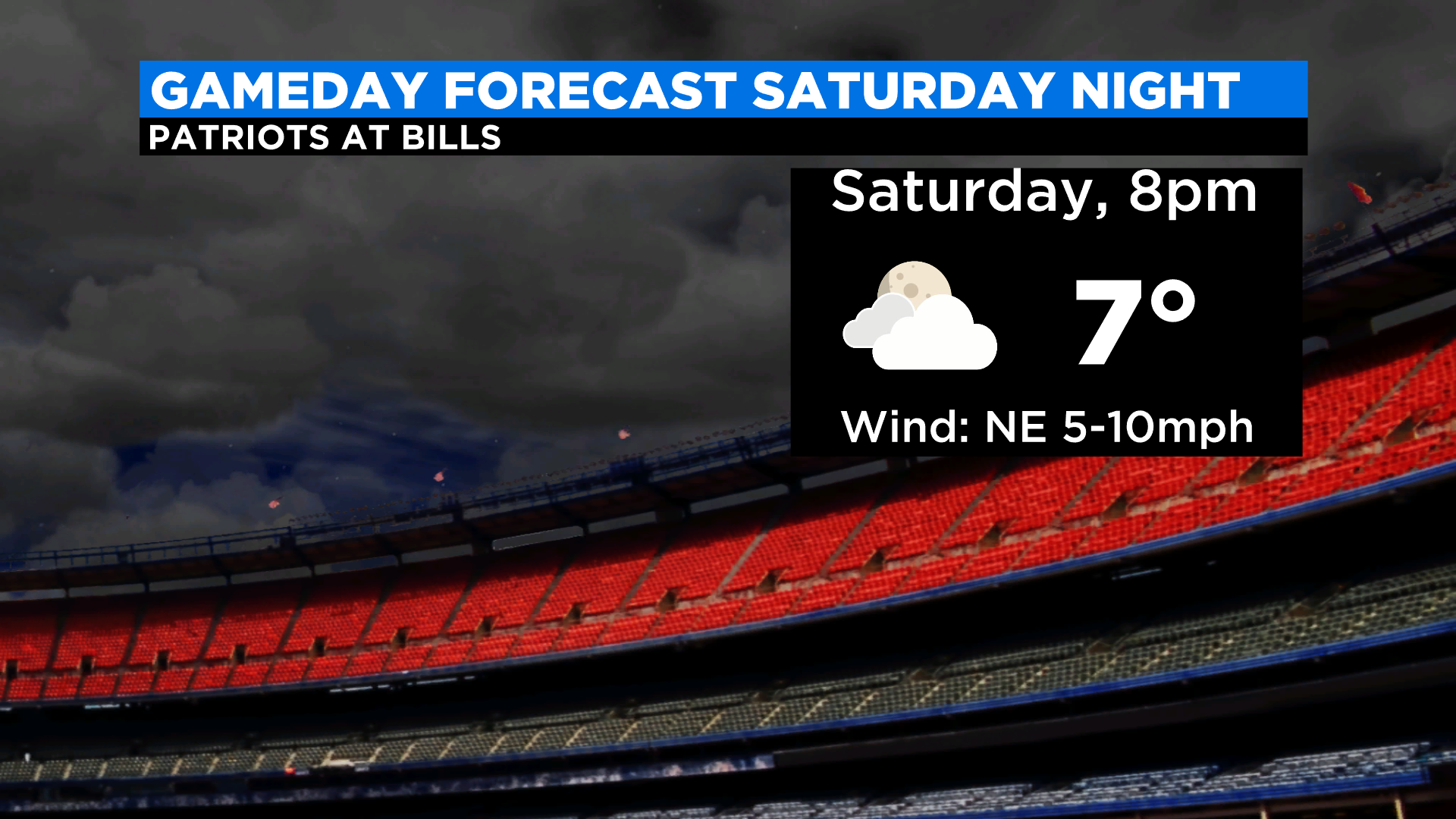
(WBZ-TV Graphic)
The forecast for this Saturday night at kickoff: 7 degrees. Wind chills won’t be all that low as winds will remain fairly light, but as we saw back in early December, strong winds might actually have helped the Patriots.
I might even give the Pats a slight edge if there were snow in the forecast. Surely Belichick would come up with a way to win in the snow, but alas, we can’t count on that either. Looks dry Saturday in Buffalo, no big storms, no lake effect, nada.
Sounds like the Pats are going to have to win the old fashion way. Mac is going to have to throw the ball and the Patriots defense is going to have to step up to the occasion.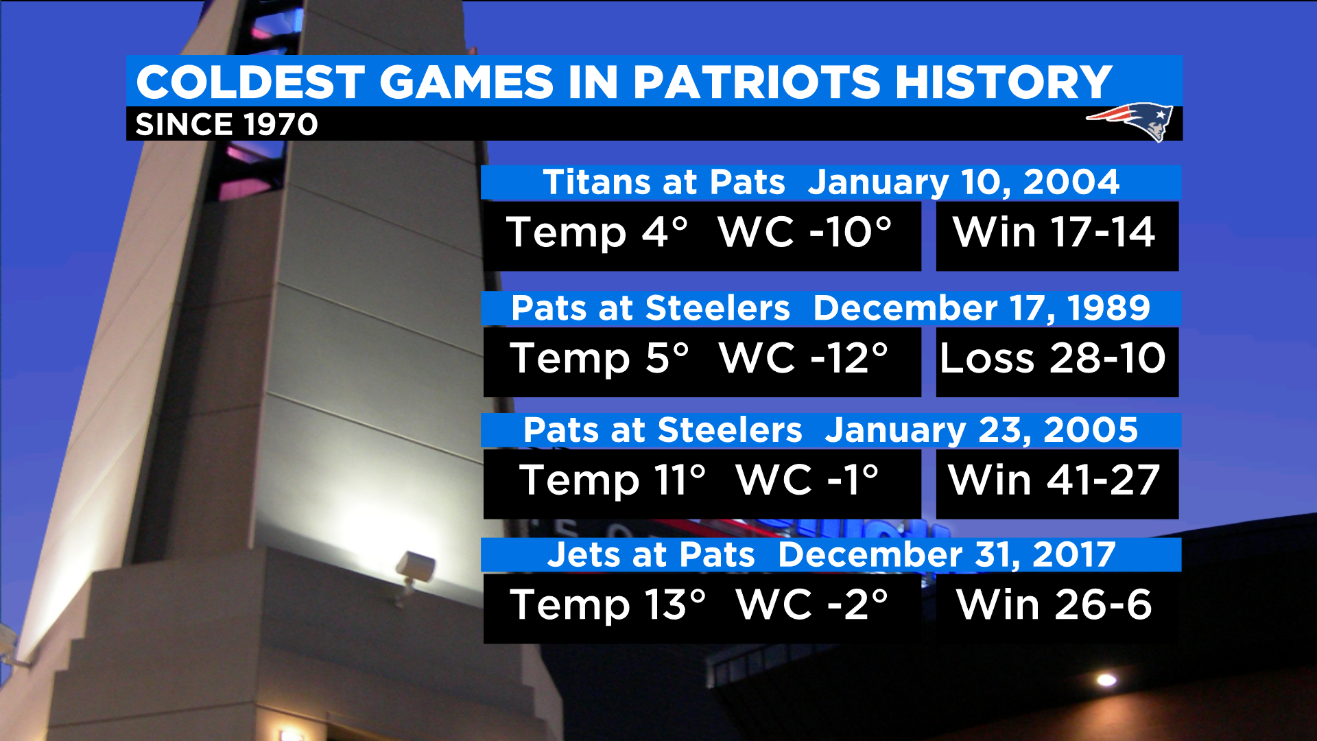
(WBZ-TV Graphic)
Hard to imagine, but a kickoff temperature of 7 degrees on Saturday night would be the third coldest game the Patriots have ever played in! The coldest game in Patriot history was in Foxboro on Jan 10, 2004 with a temperature of 4 degrees at kickoff (17-14 Pats win). Next up, December 17, 1989 in Pittsburgh, it was 5 degrees at kickoff (Pats lost 28-10).
I was surprised to find that of all the terrible weather games the Patriots have played in Buffalo over the years, the coldest kickoff temperature in their history was only 22 degrees on December 26 of 2010.
(WBZ-TV Graphic)
In short, this weekend’s cold will be fairly historic as far as Patriots games go whether in Buffalo or anywhere for that matter.
I would submit that playing in the cold is more about being in the right mindset than anything else. There are things you can do in strong winds or snow to gain an advantage on the field … in the bitter cold it is more about pain tolerance.
Does this Patriot team have what it takes? I can’t wait to find out!
Click here for Westford snow storm data and past totals or select “Winter Snowfall“ under “Pages” on the left hand side.
For more up to date forecast information follow me on Twitter (@terrywbz) or follow the WBZ weather team on Facebook, search WBZWeather
Reader Comments