


Heavy Snow Bands Could Make For Treacherous Tuesday Morning Commute Around Boston
By Terry Eliasen, Meteorologist, WBZ-TV Exec. Weather Producer
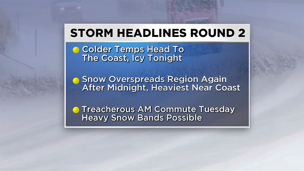
BOSTON (CBS) — Had enough of winter yet? Two days into meteorological winter and we have already had hundreds of school closings and numerous slippery commutes. . . and we do it all over again Tuesday.ADVERTISING
Monday night went pretty much as planned with a general 5-10” inland of I-95 and lesser amounts the closer you got to the coastline. Monday was mostly a lull with just a smattering of rain and snow showers. I think most folks would be A-OK with sticking a fork in this one and declaring it DONE. The truth is, we are far from it.
(WBZ-TV graphic)
A secondary low pressure area is currently spinning off of New Jersey and is set to make a run at New England – the second such storm in two days to do so. This one will be a bit different from the last though. While Monday morning’s snowfall jackpot was located in the typical “snowbelt” areas (north and west of Boston), Tuesday morning’s snowfall will be most intense at the coastline. And while nearly all the snow accumulation occurred overnight (done by the morning commute) on Monday, Tuesday’s timing will be a bit more problematic, peaking DURING the morning drive. More school closings, more travel headaches.
TIMELINE:
Just after dark Monday, temperatures will crash at the coast. So those areas that had been above 32 and raining on Monday will suddenly freeze up between 4-8 p.m. . . this includes Cape Ann, through the North Shore, and Boston and immediate South Shore. Rain showers will flip to snow showers and some light additional accumulation will begin again.
Between 8 p.m. and 4 a.m. most areas will be snowing, but overall it will be light to at times moderate. So, a few additional inches here and there, with a slightly steadier/heavier snowfall north and west of Boston.
The main course from part two will come between 4 a.m. and midday on Tuesday. This is when the storm will make its closest pass offshore and when we are most concerned about significant additional snowfall in Eastern Mass. There will be some very heavy/intense snow bands on the western edge of this storm, which will come perilously close to our coastline. Should these bands stay just offshore, we get a general light to moderate snow and call it a day. Should they push just 10-25 miles westward, it is a whole new ballgame and we could see heavy, blinding snowfall for several hours Tuesday morning across Eastern Mass.
Right now we think they will clip our eastern areas, so we have bumped the new snowfall accumulation up a bit from the Maine coastline all the way down through the South Shore of Massachusetts.
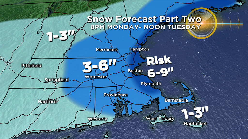
NEW SNOW ACCUMULATION:
(WBZ-TV graphic)
From 8 p.m. Monday through midday Tuesday:
1”-3” Far away from the storms center, Western Mass., Vermont and up into Central and Northern New Hampshire.
3”-6” All of Central and Eastern Mass. from Worcester County eastward and all of southern New Hampshire and Maine.
Possibility of 6-9” Should those intense snow bands push just onshore, the immediate coastline of Maine, New Hampshire, Essex County, Suffolk County and Plymouth County.
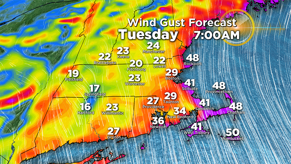
WINDS:
(WBZ-TV graphic)
Northerly gusts along the coastline on Tuesday morning will reach 30-50 mph (similar to today). . . but combine those winds with some heavy snow and you could get near whiteout conditions at times during and after the Tuesday morning commute. Once the snow tapers and the storm begins to pull farther out to sea, the winds will gradually diminish through the overnight hours.
SNOWMELT. . . OR NOT:
(WBZ-TV graphic)
Temperatures for the remainder of the week will top out in the 30s for highs so no immediate or significant snowmelt. There are signs of somewhat milder air next week, but for now it appears we will keep our new blanket of white.
Follow Terry on Twitter @TerryWBZ
Click here for Westford snow storm data and past totals or select “Winter Snowfall“ under “Pages” on the left hand side.
For more up to date forecast information follow me on Twitter (@terrywbz) or follow the WBZ weather team on Facebook, search WBZWeather
Reader Comments