


For many New Englanders, Memorial Day Weekend is the unofficial start to summer. Barbeques, boats and beaches rise to the top of everyone’s minds. Average high temperatures finally climb to 70 degrees, sunsets are after 8pm and the green colors have finally returned to the landscape. All seems right with the world once again; all we need is the weather to cooperate. Unfortunately, many times, that is where the dream ends.
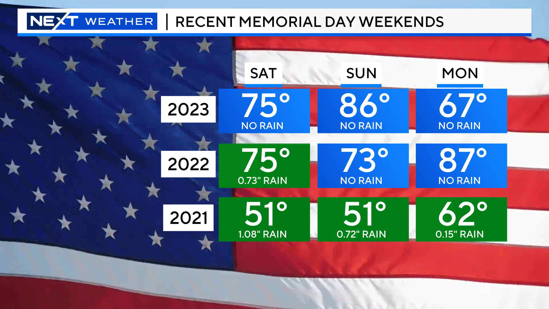
Anyone remember 2021? I hate to bring it up, but that is a shining example of just how miserable the weather can be here on Memorial Day Weekend…seriously, it doesn’t get any worse! Rain fell each day, there was no sunshine and temperatures didn’t climb above the upper 40s and low 50s on Saturday and Sunday.
The last couple of years we have had much better luck.
In fact, Memorial Weekend was an absolute stunner in 2023. As it turned out, that was basically the last nice weekend we had for the rest of the year!
The news this year is mostly good! I wouldn’t call it perfection, but I think most folks will happy with what is in store.
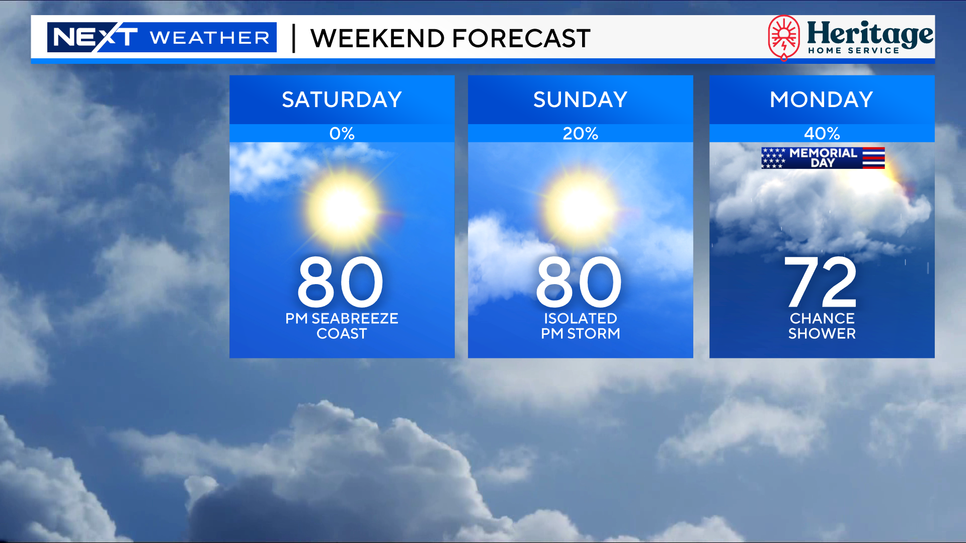
SATURDAY
Sky Conditions: Mainly sunny for most of the day, increasing high clouds in the afternoon and evening. Rain free!
Temperatures: Generally, in the 70s to near 80. There will be some localized, light sea breezes along the Coast, particularly over southeastern MA, so highs there will be about 5-10 degrees cooler.
Humidity: Very low, comfortable
Winds: Very light, mainly out of the west, again flipping around a bit right at the Coast.
Overall rating (1-10): 9
SUNDAY
Sky Conditions: A mix of sun and clouds, with a bit more clouds than Saturday. There is a 10-20% chance of a pop-up shower in the afternoon.
Temperatures: Similar to Saturday, in the 70s to near 80. Again, 5-15 degrees cooler along the South Coast and Cape Ann and many southeastern MA beaches.
Humidity: Ticking up a bit, higher than Saturday, I’d call it a bit humid
Winds: Light and mainly southerly, hence the cooler temperatures along south facing beaches.
Overall rating (1-10): 7-8
MONDAY
Sky Conditions: Lots of high clouds early and increasing low clouds in the PM. The least sunny day of the weekend. About a 20-40% chance of a shower during the daylight hours, much higher risk overnight into Tuesday AM.
Temperatures: The coolest day of the stretch. Highs will top out in the low 70s north and west of Boston. Anywhere near the Coast, it will be cooler (60s) due to an onshore wind.
Humidity: Dewpoints around 60 will make it feel just a touch humid.
Winds: Increasing south-southeasterly winds throughout the day, 10-20mph in the afternoon.
Overall rating (1-10): 6-7 (bit lower at the Coast)
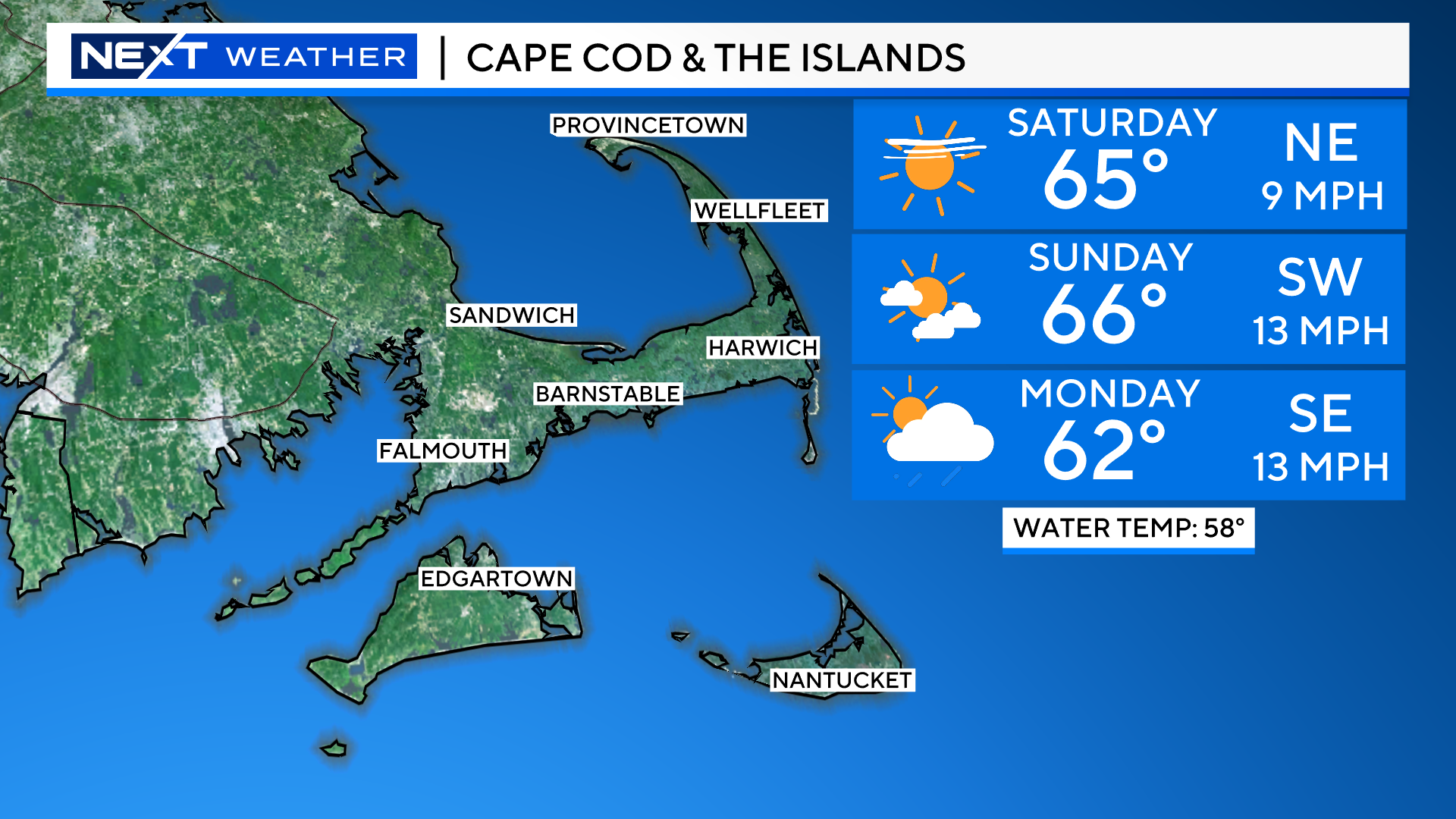
Headed to the Ocean?
High tides will generally occur in the early afternoon, winds light Saturday and Sunday, increasing on Monday.

May typically isn’t the ideal time to go to the Cape and Islands simply because the Ocean is still so chilly. There will be a good deal of sunshine there this weekend though!
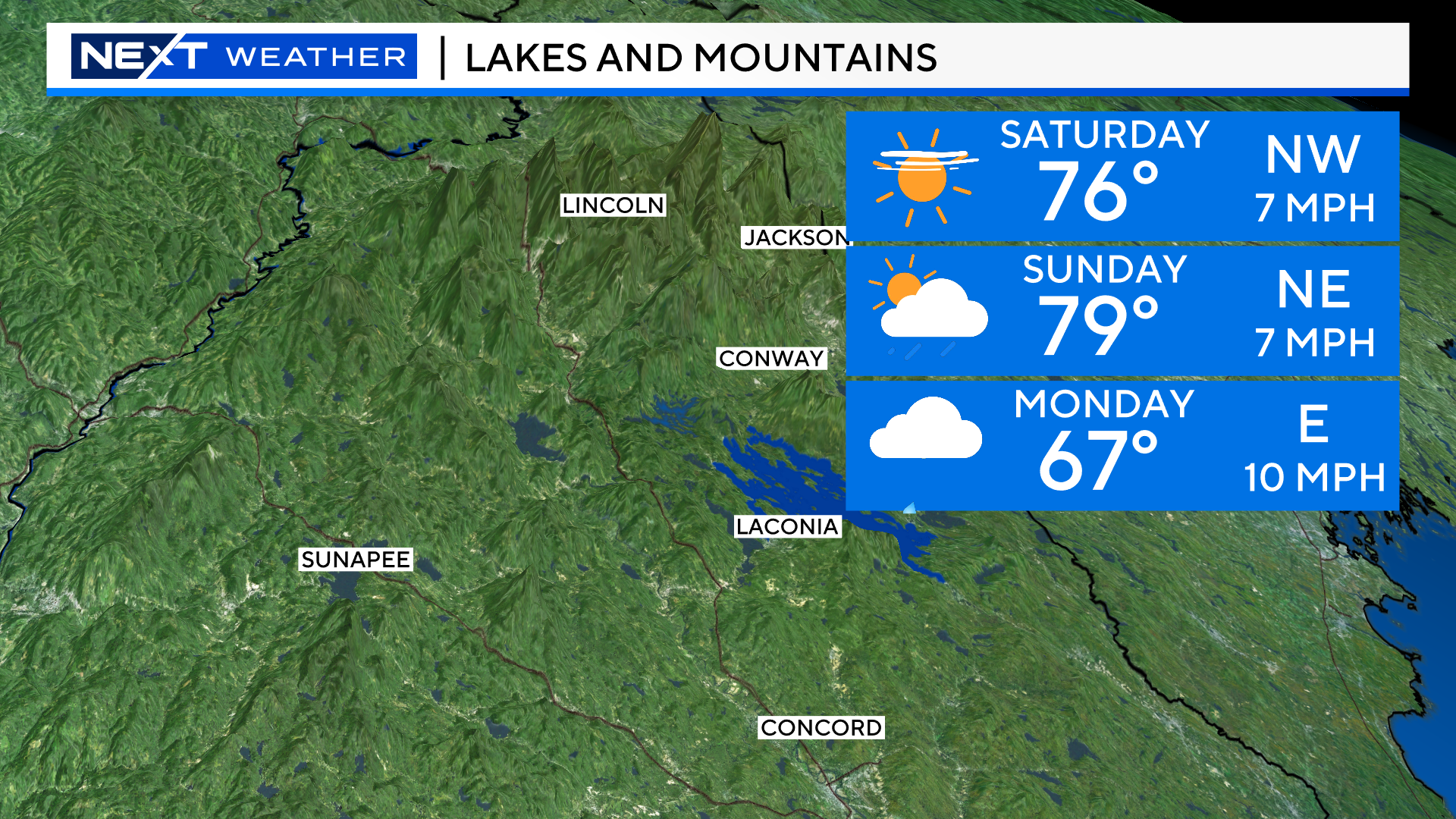
It will be a great weekend for a hike up north! Just a spot shower Sunday PM. More cloudiness arrives Monday.
All in all, I’d say we are off to a great start to the summer season!
Stay tuned to WBZ-TV, WBZ.com and CBS News Boston all weekend long for fresh and frequent updates!
NOAA is predicting an 85% chance of an above normal season and just a 5% chance of a below normal season.
They are predicting a whopping 17-25 named storms, between 8-13 hurricanes of which, 4-7 will become major. These numbers are all nearly double the seasonal averages.

There are two main reasons for the extraordinary forecast…
- El Nino has faded. Typically, during El Nino’s, there is a large amount of wind shear in the Tropical regions which often stunts the growth of tropical systems. In its place, a La Nina is expected to emerge this summer. You can already see the classic La Nina signature unfolding in the Pacific Ocean, those cooler than average waters off the coast of South America. Many of our most active hurricane seasons have occurred during La Nina’s which act opposite to El Nino’s, reducing wind shear across the Tropics.

- Our Oceans are extremely warm right now compared to averages. Historically speaking, as of right now, the waters in the Tropical Atlantic are near or at record warm levels. Hurricanes feed off of warm water, particularly above 80 degrees. There will be an abundance of “fuel” for any tropical systems to feed off of this summer and fall across the Atlantic.
Even at this early date, the water temperatures across the Gulf of Mexico and Caribbean are already well into the 80s, and in some cases nearing 90 degrees.

Naturally, the million-dollar question is, how many of these hurricanes will strike land and the U.S.? That is impossible to tell. However, given the level of activity that is expected, and the warm waters close to the southeast Coastline and across the Gulf Coast, the risk of landfalls are high.
As always, that chance is much lower the farther north you live along the East Coast given the cooler water up this way.
It would be an understatement to say the New England is “due”. It has been 33 years since we had a landfalling hurricane in New England (Bob, 1991). That doesn’t necessarily increase our odds for this year, but it does mean that many of the folks currently living in our area either have never experienced a hurricane or don’t remember the last time we did. It is not a matter of IF, but WHEN. Given the amount of erosion our Coastline has experienced in recent years combined with the residential and commercial buildup since 1991, it is safe to say that when the big one does hit New England, it will be a devastating and costly event.
Will that be this year? Maybe…simply put, the more tropical systems in the Atlantic Basin, the higher the odds that one or more could sneak up the Coast.
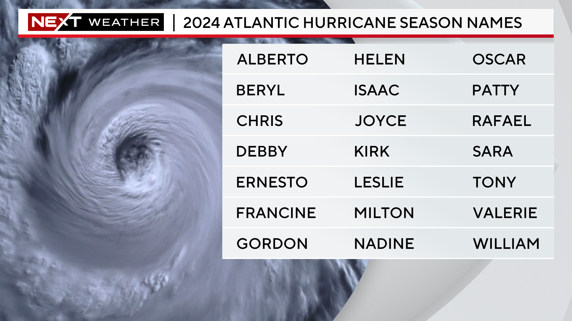
Last but not least, here is the list of names for the 2024 season. This list is used in rotation and is recycled every 6 years. This could be another year where we need to extend beyond this list of 21 names to an “alternate list”.
Click here for Westford snow storm data and past totals or select “Winter Snowfall“ under “Pages” on the left hand side.
For more up to date forecast information follow me on Twitter (@terrywbz) or follow the WBZ weather team on Facebook, search WBZWeather
Reader Comments