I am running out of words. Running out of ways to “look on the bright side”. And, perhaps worst of all, we are running out of fall weekends and time to enjoy what typically is the best that New England has to offer.
Two weeks from Sunday we will be turning the clocks back. The sun will be setting around 430pm. For me, that is usually the time when I “let go” of fall and start preparing for the long winter ahead. The problem this year is I feel like we haven’t had a fall. We have been robbed.
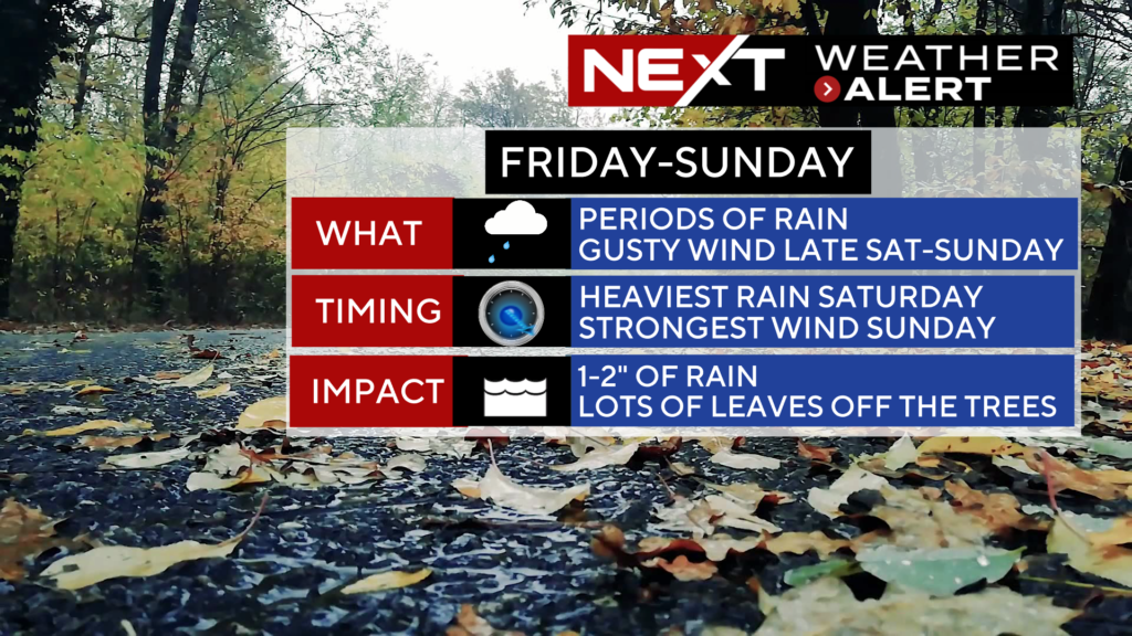
Ironically, for the first time this season, I saw some really nice fall color on my ride to work today. Great, thanks…too little too late. After a few inches of rain and a period of very gusty winds this weekend, much of those leaves will be flying off the trees.
So, without further ado, here is your detailed weekend forecast, viewer discretion advised.
FRIDAY:
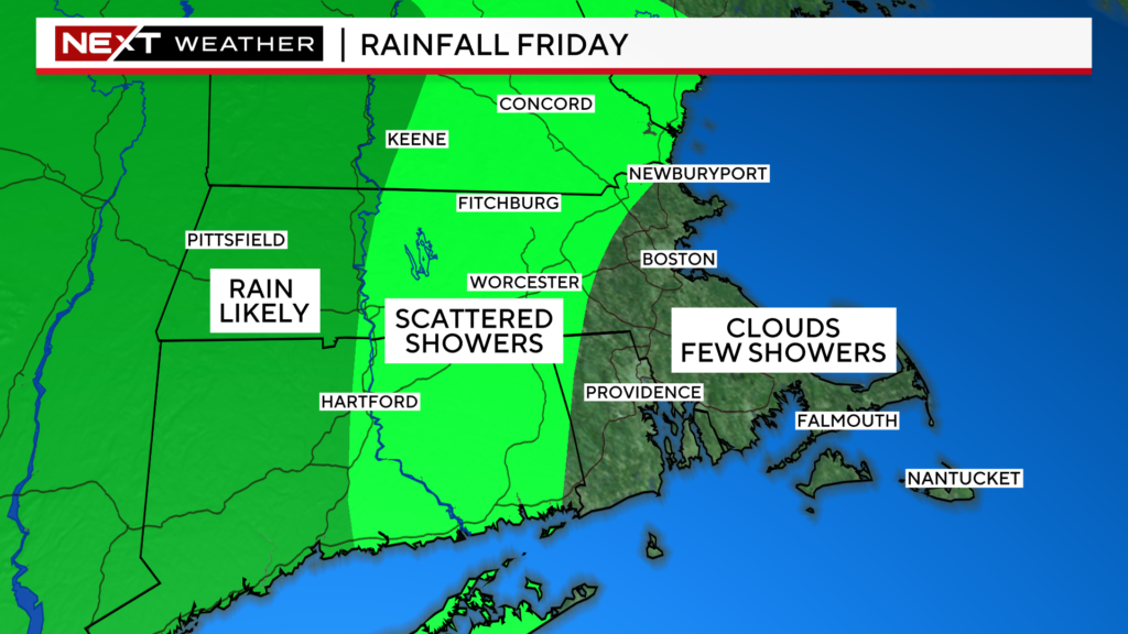
Cloudy day with most of steady rainfall in western MA. In central and eastern MA, we will see some lighter showers and drizzle for most of the day. Temperatures will be on the mild side, mainly in the mid 60s. All in all, not a terrible day in eastern MA, cooler and wetter the farther west you travel.
SATURDAY:
Yuck.
Periods of rain all day long, essentially a washout.
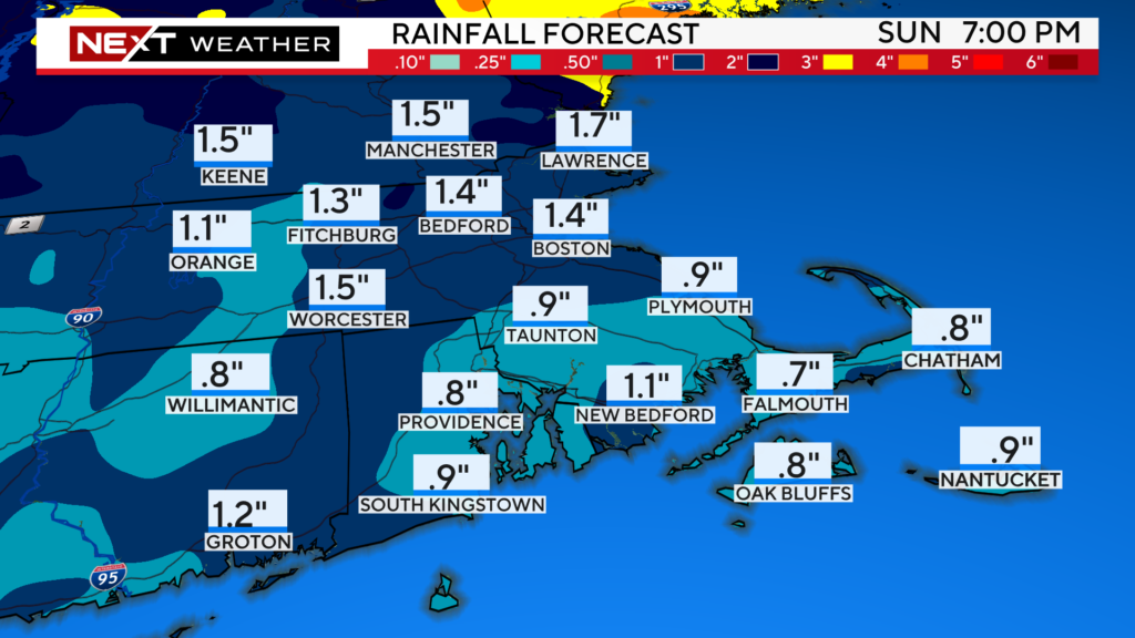
Expect 1-2″ of rainfall through Saturday night in most of the area.
Looking for some good news? It won’t be particularly cold, highs near 60.
The winds will pick up later in the day, gusting 20-40mph overnight and into Sunday.
SUNDAY:
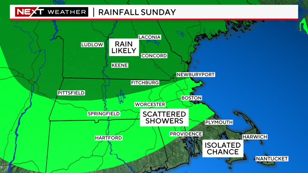
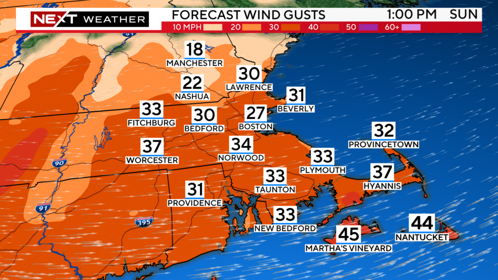
A windy, showery day. Westerly winds will gust between 20-40 mph all day long. Rain showers will be steadiest and heaviest north of the MA/NH border but will tend to drift southward throughout the day.
The winds will be swirling around Gillette Stadium for the 1pm game. It will also make for a very choppy Charles River for the regatta.
And, as usual, the weather turns much nicer next week with several days of sunshine. We may make one last run at 70 degrees later in the week!
The National Weather Service released their 2023-2024 winter forecast on Thursday.
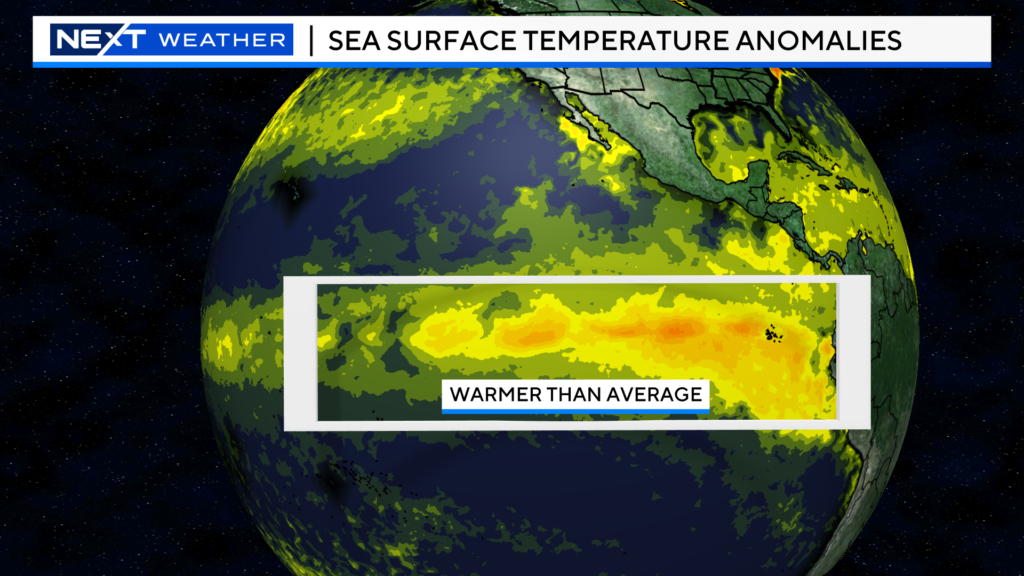
Not surprisingly, they stated that a very strong El Nino, already in place, will be the predominant driver of Global weather going forward and throughout this winter.
Reminder, El Nino is a warming of Pacific Ocean sea surface temperatures off the west coast of South America.
These warmer than average water temperatures start a domino effect throughout the atmosphere, leading to a variety of effects depending upon where you live.
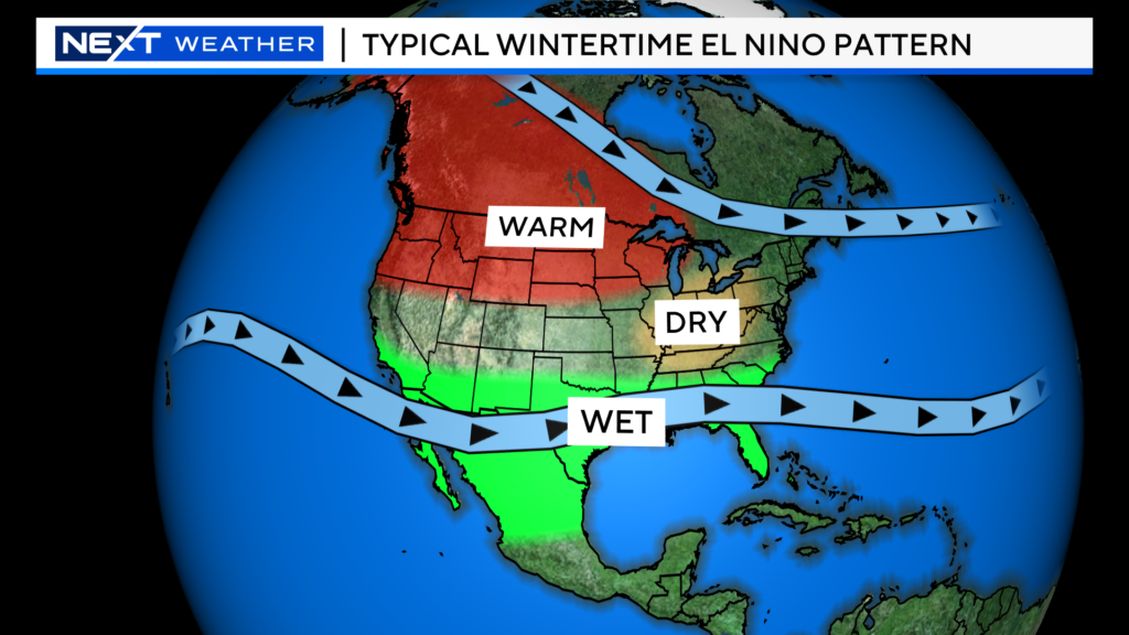
In a typical wintertime El Nino setup, you tend to get wetter than average conditions in the south and milder than average temperatures across the northern-tier.
Here is the official NOAA winter temperature forecast…you can see that in New England, the NOAA forecast shows a high probability of a warmer than average winter (Dec-Jan-Feb), particularly for portions of far northern New England.
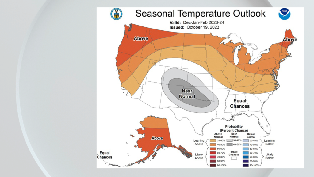
This doesn’t mean that we won’t have some cold periods, just that taken overall, the three winter months will likely average out milder than normal.
As for precipitation, NOAA highlights a higher probability of above average precipitation across much of the southeastern U.S.
The above average precipitation forecast also extends up the East Coast, including parts of southern New England.
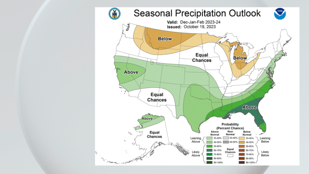
Of course, this leads to the big question…will this come as rain or are we in for a bunch of snow? NOAA says this is less clear. While they are forecasting warmer than average temperatures for our area, that does not preclude us from getting some big snowstorms, It only takes one (or a few) big nor’easters to tip the scales and the perception of the winter.
Looking back at other winters with strong El Nino’s, nearly all of them finished with below average snowfall in the Boston area and most of New England. Many times, we end up with a lot of mixed precipitation events in El Nino winters.
Our WBZ Weather Team will issue their own winter forecast (focused on New England) in November. Stay tuned!
Click here for Westford snow storm data and past totals or select “Winter Snowfall“ under “Pages” on the left hand side.
For more up to date forecast information follow me on Twitter (@terrywbz) or follow the WBZ weather team on Facebook, search WBZWeather


Reader Comments