


It’s coming…
After a week’s worth of warnings, snow maps, cones of uncertainty, and scenarios, it’s time to buckle up and ride it out.
This is not a storm to take lightly. I know, I know… we are hardy New Englanders and we have seen it all, I hear you. This will not be your garden variety snowstorm however. If at all possible, you should plan to be home for the day on Saturday. If you must travel, make it early Saturday morning. While the snow will be over by Sunday, there will undoubtedly be prolonged travel delays which could even last into early next week. It will take some time to clean this up. There is also a real risk of wind damage and power outages, particularly over Cape Cod.
HISTORY IN THE MAKING?
A storm of this magnitude doesn’t occur very often. The last time we had blizzard conditions in our area was nearly 4 years ago, March 13, 2018. You have to go back to either January of 2018 or the snow blitz of 2015 for snowfall totals like what we are projecting. The last time Boston had 2 feet of snow in one storm was exactly 7 years ago, January 27, 2015: 24.6”…that also happens to be our biggest January snowstorm in Boston’s recorded history. Will this storm register as one of our biggest ever recorded? Time will tell. The most important factor to watch once the storm gets going will be the heavy banding. In our most powerful snowstorms the jackpot areas are always underneath the intense snow bands. The exact location of these are very difficult to forecast, similar to a line of thunderstorms in the summertime…very powerful and impactful for a given area, but a few miles away you get a much different experience. If Boston is to set a record Saturday, the City will need to spend several hours beneath one of these bands, which could drop in excess of 3” of snow in an hour. Southeastern MA (Plymouth, Bristol and Barnstable counties) are the most likely areas to get rocked with banding. Next up would be the immediate coastline from Boston through Cape Ann. Records are hard to set…we have about 150 years of record keeping here in Boston. I don’t care what the models say, there is a reason why we have so few storms that reach 2 feet or more. I would rate setting a record at a long shot.
TIMELINE:
Midnight-7am Saturday: Light snow begins over a good portion of southeast MA and most areas south of the Mass Pike at Midnight and spreads northward. By 7am it is snowing in all of Southern New England and as far north as Manchester or Concord NH. By 7am there will only be a coating to a few inches north of the Pike and 2-4” south of the Pike.
7am-1pm Saturday: The snow intensity increases hour by hour with the heaviest bands located over southeastern MA. By 10am we start to see some of those intense snow bands setting up in southernmost areas and the snowfall rates reaching 1-3” per hour. We could start to approach blizzard conditions in this window with winds approaching their peak. By 1pm I would expect 3-6” north of the Pike and 6-12” south of the Pike.
1pm-7pm Saturday: The storm will stay at peak for most of this timeframe. With the wind gusts and the snow intensity peaking together, we will reach white-out conditions in many areas, especially near the Coastline. Some areas could exceed 3” per hour snow rates. By 6-7pm there will be a noticeable decrease in snow intensity, the heavy bands will be losing their grip and the majority of the accumulation will be over.
7pm-Midnight Saturday: The snow tapers to moderate and then light and shuts off completely by midnight.
WHEN TO SHOVEL/SNOW BLOW
In a storm this big, many folks may be thinking about taking a couple shifts to clean it up. Going out in the middle of this storm will be rough. With the winds howling and the snow being so light and fluffy, you may get one area down to pavement and then minutes later see it covered again thanks to a big gust of wind. If it were me, I’d wait until it were over. Maybe head out after 7pm. There may be an additional inch or two after 7pm but you can get the majority. Or, to heck with it, stay inside, put on a movie and clean it up Sunday morning! The winds will be much lighter by then and temperatures will be similar (very cold…bundle up).
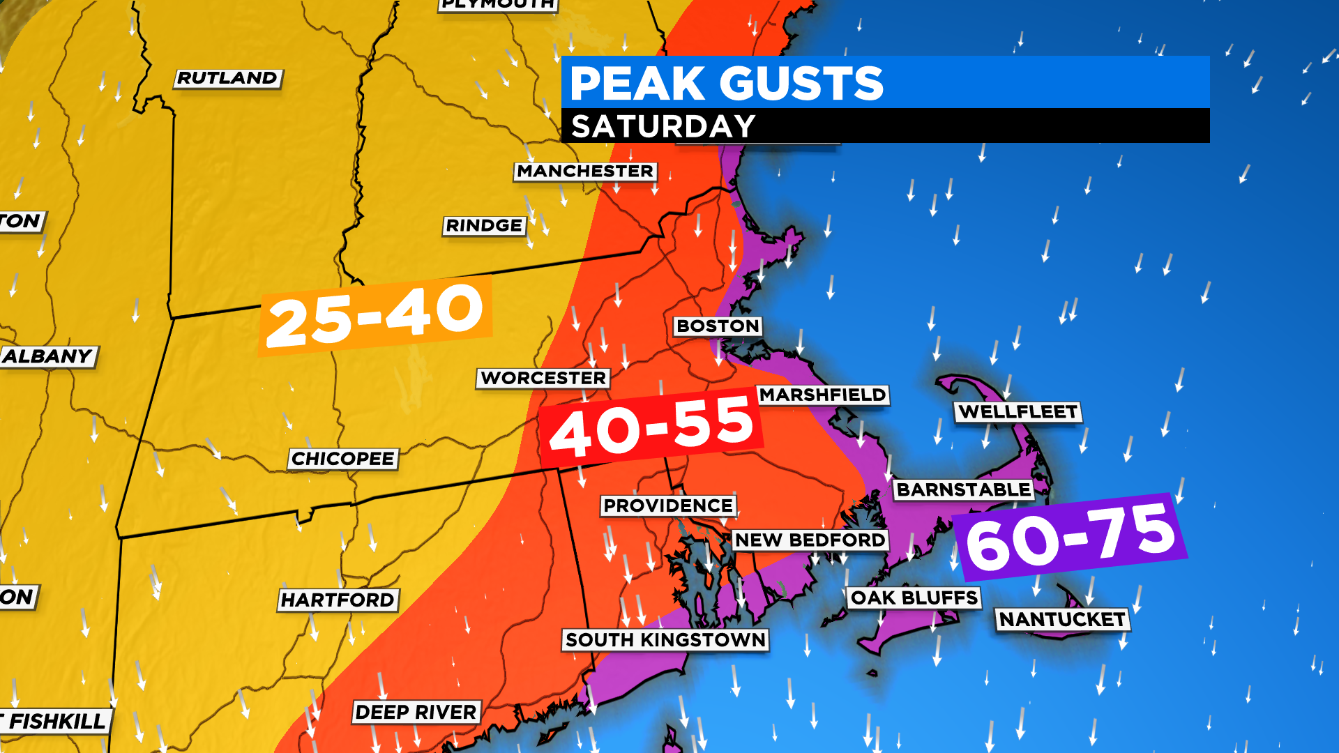
WINDS:
The peak of the wind will occur between 8am and 6pm with a slow ramp up/down in the hours prior and following.
During the peak…
60-75mph along the entire immediate coastline from southern Maine through Cape Cod and the Islands…this is where power outages and wind damage would be most likely
40-55mph west of I95 back to about 495
25-40mph through most of central and western MA
COASTAL FLOODING:
We will be spared the worst case scenario with this storm. The highest astronomical tide of the day occurs at 8am, just about the time when the storm is ramping up. Therefore, we expect minor to moderate flooding in the morning. The evening high tide, between 8-9pm, is nearly two feet lower (astronomically) than the morning tide. So, while winds will be cranking and seas much more rough we have a little more wiggle room. Also of note for the nighttime high tide, the winds will be turning more to the north-northwest, more of a parallel direction for most of coastline. The exception would be over the Cape Cod Bay and Cape Ann (northside), those areas are likely to be hit hardest in the evening.
HOW MUCH SNOW:
12-18” across all of central and eastern MA, most of southern New Hampshire and a good portion of Cape Cod
6-12” western MA up through Vermont
Also 6-12” for the Outermost Cape and Nantucket with a much wetter and heavier snow
18-28” within the heavy bands that will set up on Saturday…this is crucial and these can be hard to pinpoint, especially this far in advance. Right now it appears that the highest likelihood of banding lies over southeastern MA (in Bristol and Plymouth counties) up through Boston and Cape Ann… There could be another local jackpot in western Middlesex county and Worcester county.

THE FLUFF FACTOR:
The snow will be very light and fluffy with temperatures being quite cold throughout the storm. A “typical” liquid to snow ratio in a snow storm is about 10:1, meaning 10” of snow for every one inch of liquid. We anticipate ratios near 20:1 in this storm, major fluff. Trying to measure the snow will be exceedingly difficult due to strong winds creating huge drifts.
We will continue to update the situation as new data comes in. We urge that you stay tuned in order to stay safe. We will have you covered on CBSBoston.com, WBZ-TV and CBS Boston News
Click here for Westford snow storm data and past totals or select “Winter Snowfall“ under “Pages” on the left hand side.
For more up to date forecast information follow me on Twitter (@terrywbz) or follow the WBZ weather team on Facebook, search WBZWeather
Reader Comments