


Blockbuster. Blizzard. Historic. It’s all on the table. We may be closing in on one of the biggest nor’easters in recent memory. Confidence continues to increase that a monster, multifaceted coastal storm is about to unleash its full fury on New England.
We are forecasting snow in feet, winds over 70mph and several hours of white-out, blizzard conditions.
If you have been following along all week, we have been discussing several possible tracks and scenarios. Our “sno-cone of uncertainty” started out several hundred miles wide and now has shrunk to about a 50-100 mile zone. About 80-90% of all possible tracks within our cone would produce blockbuster snowfall. There remains about a 10-20% chance of a track a bit farther east which would lower the snowfall and impacts to some degree in our area…but again, those possibilities are shrinking.
This storm should NOT be taken lightly. If at all possible you should plan to be home for the day on Saturday. If you must travel, make it early Saturday morning. While the snow will be over by Sunday, there will undoubtedly be prolonged travel delays which could even last into early next week.
A storm of this magnitude doesn’t occur very often. The last time we had blizzard conditions in our area was nearly 4 years ago, March 13, 2018. You have to go back to either January of 2018 or the snow blitz of 2015 for snowfall totals like what we are projecting. The last time Boston had 2 feet of snow in one storm was exactly 7 years ago, January 27, 2017: 24.6”…that also happens to be our biggest January snowstorm in Boston’s recorded history.
Ok let’s get to the details…
TIMELINE:
Light snow begins just after midnight Friday night, mainly over far southeastern MA. By dawn on Saturday, it is snowing light to moderate over southeastern MA and lightly north and west of Boston. Over the course of Saturday morning, the snow slowly ramps up in intensity from south to north. If you must travel on Saturday, do so as early as possible. The brunt of the storm comes between 10am and 10pm Saturday. This is when we will start to develop very heavy snow bands which will pinwheel through our area from south to north. Snowfall rates in some of these bands could reach 1-3” per hour…absolutely blinding in the strong northeast winds. We could teeter on blizzard conditions at times, especially near the Coastal communities of Essex, Suffolk, Plymouth and Bristol counties. Expect major blowing and drifting of snow. The snow would finally begin to taper after 10pm from west to east…I would say about 90% of the total storm accumulation would be done by 10pm…just some leftover lighter snow showers through the early morning hours of Sunday.
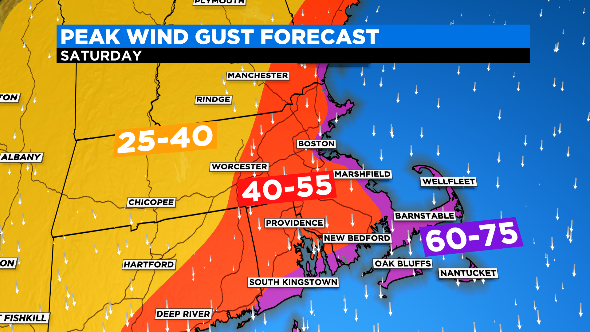
WINDS:
60-75mph along the entire immediate coastline from southern Maine through Cape Cod and the Islands…this is where power outages and wind damage would be most likely
40-55mph west of I95 back to about 495
25-40mph through most of central and western MA
COASTAL FLOODING:
It appears we will be spared the worst case scenario with this storm. The peak of the winds appears to arrive around low tide (2pm). The highest astronomical tide of the day occurs at 8am, just about the time when the storm is ramping up. Therefore we expect minor to moderate flooding in the morning. The evening high tide, between 8-9pm, is nearly two feet lower (astronomically) than the morning tide. So, while winds will be cranking and seas much more rough we have a little more wiggle room. Also of note for the nighttime high tide, the winds will be turning more to the north-northwest, more of a parallel direction for most of coastline. The exception would be over the Cape Cod Bay and Cape Ann (northside), those areas are likely to be hit hardest in the evening.
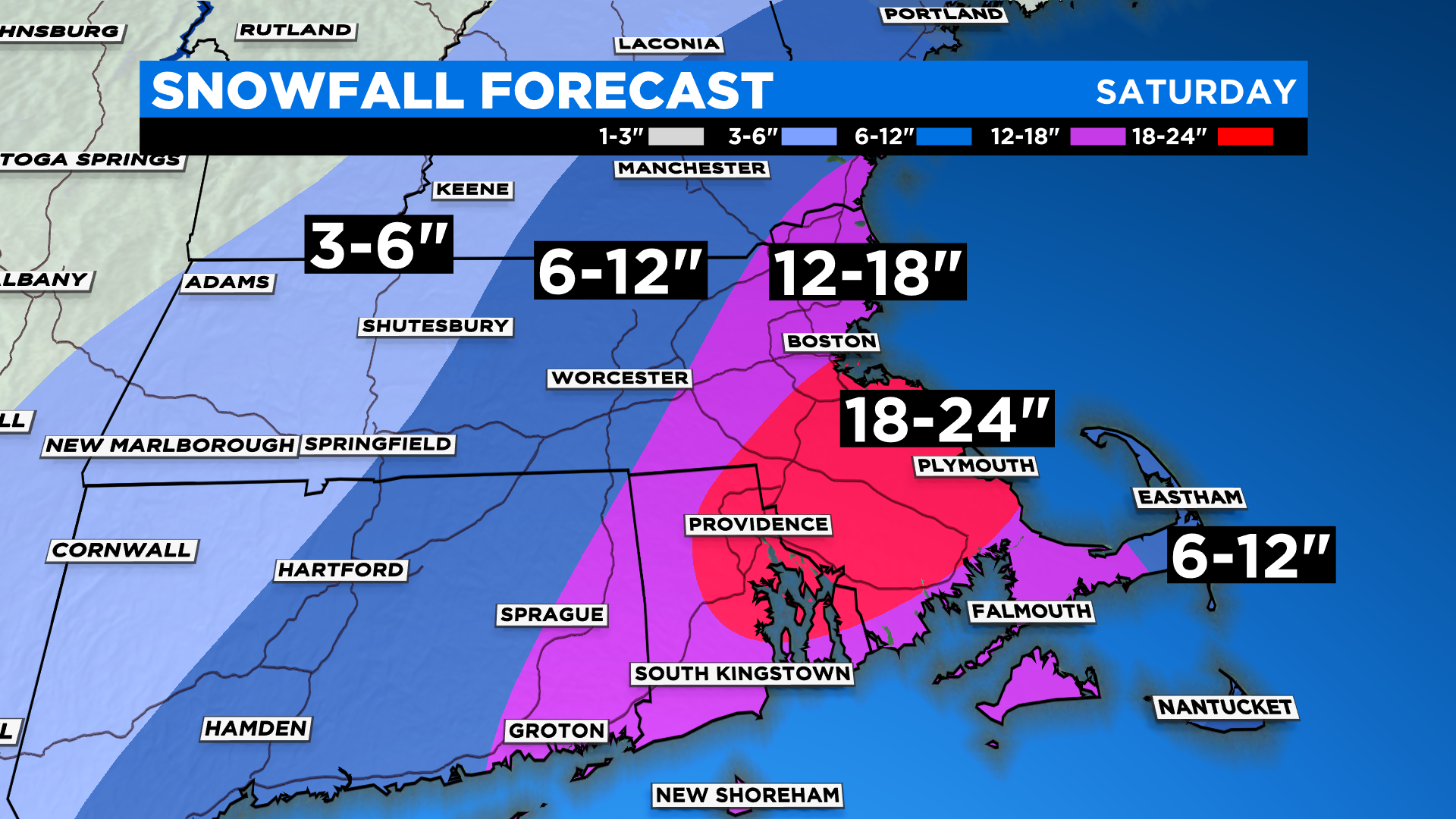
HOW MUCH SNOW:
Drum roll…
12-18” across most of eastern MA, inside of 495 and down through a good portion of Cape Cod
6-12” from 495 north and west through most of Worcester county and southern New Hampshire
Also 6-12” for the Outermost Cape and Nantucket with a much wetter and heavier snow
18-24” (WOW) in a corridor just south of Boston into interior Plymouth and Bristol counties and parts of Norfolk county
And these number could go higher! In a storm like this, 30” somewhere is not out of the question.
THE FLUFF FACTOR:
The snow will be very light and fluffy with temperatures being quite cold throughout the storm. A “typical” liquid to snow ratio in a snow storm is about 10:1, meaning 10” of snow for every one inch of liquid. We anticipate ratios between 20:1 and 30:1 in this storm, major fluff. Trying to measure the snow will be exceedingly difficult due to strong winds creating huge drifts.
We will continue to update the situation as new data comes in. We urge that you stay tuned in order to stay safe. We will have you covered on CBSBoston.com, WBZ-TV and CBS Boston News
Click here for Westford snow storm data and past totals or select “Winter Snowfall“ under “Pages” on the left hand side.
For more up to date forecast information follow me on Twitter (@terrywbz) or follow the WBZ weather team on Facebook, search WBZWeather
Reader Comments