


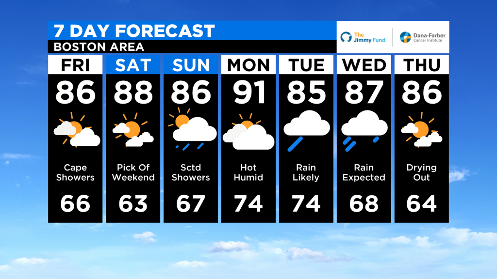
FRIDAY: Partly sunny, bit humid, 84-88
SATURDAY: Mainly sunny and hot, bit humid, 86-90
SUNDAY: Increasing clouds, few scattered showers possible very late in the day, 85-90
Will Hurricane Isaias Impact New England? Here Are 3 Potential Scenarios
By Terry Eliasen, Meteorologist, WBZ-TV Exec. Weather Producer

BOSTON (CBS) — Seems a bit early for this doesn’t it? Typically hurricane season peaks in the months of August through October, and here we are in late July and already on our ninth named storm, Isaias. The fact we made it to the “I” storm this early is also quite remarkable – the average date for reaching “I” in the Atlantic Hurricane Season is October 4th! Back in 2014 we never even made it to “I”!
We knew this would be an active hurricane season, given the weak La Nina and anomalously warm ocean temperatures in the Atlantic, and we are certainly off and running.
Isaias is currently a minimal hurricane with maximum sustained winds of 75 mph, moving northwest through the southern Bahamas. There are Tropical Storm and Hurricane warnings up for most of the island chain and well as into southern Florida.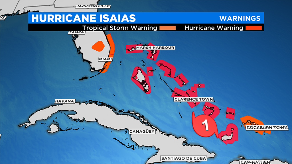
By now, you likely have seen the forecast cone from the National Hurricane Center – the track remains just offshore of Florida, comes north and makes landfall in outer North Carolina and then heads straight for New England. A few things to note regarding the track: First off with any hurricane or strong storm in the Bahamas, the entire East Coast needs to be on alert and ready for anything. While the forecast has been fairly steady over the last 24-48 hours, a small change in atmospheric conditions can lead to big shifts in track and consequently large changes to impacts along the Coastline.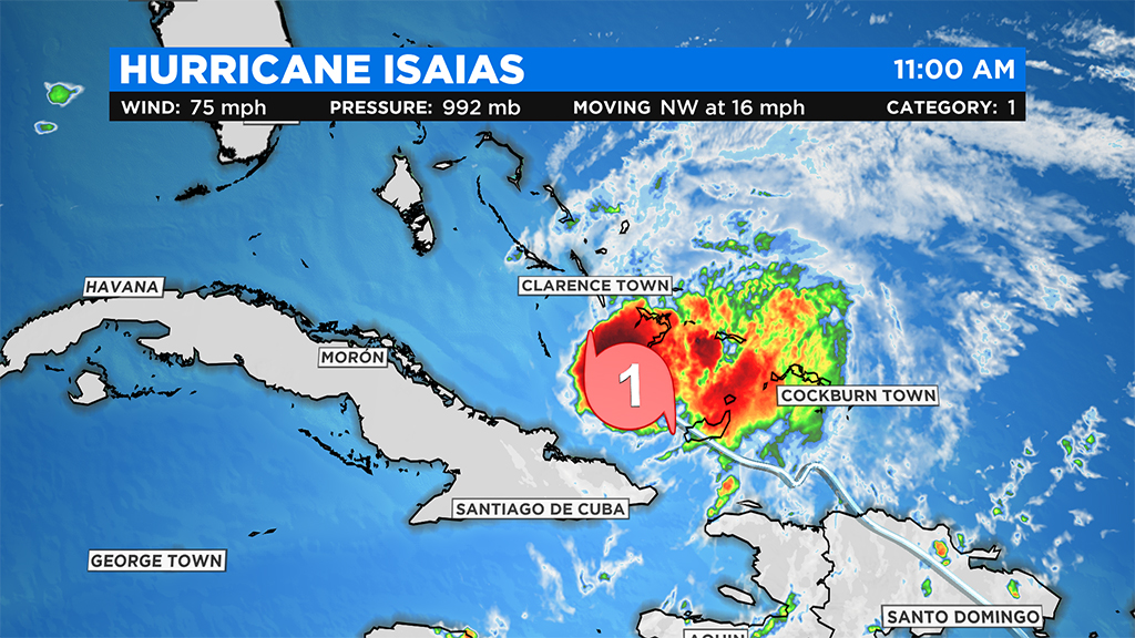
The biggest wildcard at the moment is when or if Isaias will make U.S. landfall. This is crucial as the longer it stays over open ocean, the more likely it will remain strong and perhaps even strengthen further as it heads north. If Isaias were to move over land, as some computer models are forecasting this weekend in Florida, that would likely severely weaken the storm and have massive consequences up the coastline from the Carolinas to New England.
So therefore, the next 48 hours are obviously extremely important. . . not only for folks along the east coast of Florida, but for the entire population from Florida through Maine.
Taking the most likely scenario (and the current National Hurricane Center forecast), and assuming Isaias will stay just offshore of Florida, it will likely remain a hurricane until it comes ashore in North Carolina on Monday night. From there, the time spent over land as opposed to open ocean is crucial for impacts here in New England.
We are currently examining three potential scenarios for Isaias here in the Northeast: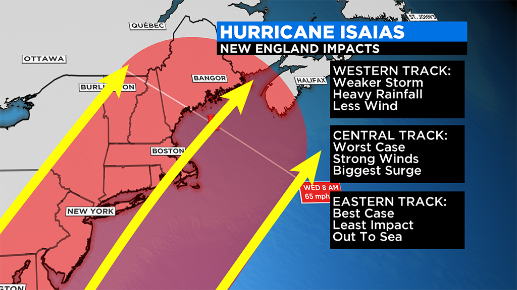
1- Isaias takes a western track, farther inland and travels north, over land, through the Mid-Atlantic and through eastern New York state or western New England on Tuesday. This would mean a much weaker storm by the time it reached our latitude, perhaps not even officially “tropical” anymore. We would experience a healthy slug of rainfall but likely very little wind or other concerns.
2- Isaias moves right down the center of the forecast cone, scraping eastern North Carolina and making a second landfall over Long Island or southeastern Mass. This would be the worst case scenario for our area. The storm would likely retain a good deal of its strength with minimal land interaction. Not only would we have flooding rainfall concerns, but significant wind damage would also be likely, especially on the eastern side of the track where winds are strongest. Finally, with the full moon coming on Monday, tides are somewhat astronomically high early next week. So, there would be some coastal flooding/surge/inundation concerns, particularly along the South Coast on Tuesday.
3- Isaias takes a right hook and passes offshore of southern New England and out to sea. We have seen this many times before. . . a big tropical system approaches, makes a close pass east of Nantucket and we barely get a puff of wind. This is still a possibility and clearly a good scenario for folks along our coastline.
Whatever impacts are felt here in New England appear to be centered around Tuesday/Wednesday of next week.
Until then, we urge that you stay tuned to updated forecasts throughout the weekend on WBZ-TV, CBSBoston.com and CBSN Boston.
Follow Terry on Twitter @TerryWBZ
Click here for Westford snow storm data and past totals or select “Winter Snowfall“ under “Pages” on the left hand side.
For more up to date forecast information follow me on Twitter (@terrywbz) or follow the WBZ weather team on Facebook, search WBZWeather
Reader Comments